Yarra Valley Trail
An immersive visitor experience that connects you with food, wine, culture and scenery of the Yarra Valley.
Get the latest project updates, join our mailing list
About the project
Yarra Valley Trail will be a game-changer for the region.
Work is underway to build a network of trails, connecting Lilydale, Coldstream, Yarra Glen, and Healesville, with a vision to link with the Lilydale to Warburton Rail Trail at Seville East and Woori Yallock, creating an iconic, valley-wide loop.
Showcasing the natural beauty of the Yarra Valley, the project will link trail users to some of Australia’s finest wineries, cultural attractions and tourism destinations, including Yarra Valley Chocolaterie & Ice Creamery, Healesville Sanctuary and Yarra Valley Railway.
Yarra Valley Trail will provide outstanding infrastructure for locals and visitors, connecting communities, increasing opportunities for recreation, nature connection and active transport, and creating local jobs.
Visitor information is available via the links below:
Yarra Valley Trails: Online Map
Rail Trails Australia: Yarra Valley Trail and Warburton Rail Trail
")
Project overview

Yarra Valley Trail Stage 1 – Lilydale to Yarra Glen
Yarra Valley Trail Stage 1 follows the historic railway corridor between Lilydale and Yarra Glen. The project is being constructed in two phases – YVT Stage 1A Lilydale to Yering and YVT Stage 1B – Yering to Yarra Glen. YVT Stage 1 will end at Yarra Glen Railway Station, recently restored by Yarra Valley Railway as they work to reinstate steam train services between Yarra Glen and Healesville.
Yarra Ranges Council thanks the Australian Government and Victorian Government for their funding support of Yarra Valley Trail Stage 1.
YVT Stage 1A – Lilydale to Yering
PROJECT STATUS: OPEN
YVT Stage 1A is complete and opened to the public in February 2020. The trail has proven to be extremely popular with pedestrians, cyclists and horse riders. Trail features include:
- Car parking at Beresford Road and Nelson Road, Lilydale
- Car parking, public toilets and a word-class pump track at Coldstream Station
- Car parking and equestrian access (horse float parking and tie up areas) at Yering Station
- A bird watching platform at the Yarra Valley Water Wastewater Treatment Plant, home to an incredibly diverse population of bird species.
A shared path at Station Street was completed in 2023, creating a direct connection between Yarra Valley Trail and Coldstream town centre.
YVT Stage 1B – Yering to Yarra Glen
PROJECT STATUS: PRE-CONSTRUCTION
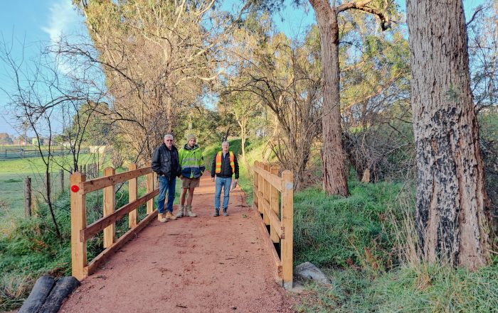
YVT Stage 1B from Yering to Yarra Glen is a complex project, requiring reconstruction of several bridges (including one over the Birrarung – Yarra River) that were lost in the 2009 Black Saturday fires. Surviving historic bridges will be refurbished in line with heritage guidelines.
YVT Stage 1B required a planning permit. Following VCAT hearings, a planning permit was issued in February 2023. Ground conditions within the railway corridor are impacting project delivery and as a result, YVT Stage 1B will be delivered in two phases, working south to north. The tender process is underway, and Council expects that construction will begin in early 2024.
")
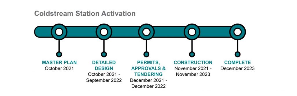
PROJECT STATUS: OPEN
Coldstream Station precinct is a large site (2.7 hectare), adjacent to Yarra Valley Trail Stage 1A and 600 metres from Coldstream town centre. The recently completed shared use path along Station Street provides a direct connection to Coldstream’s residential and commercial zones.
The site is a former railway station on the historic Lilydale to Healesville line and played an important role in the life of Coldstream for over 100 years. The site retains remnants of the former railway, including the station platform and railway sidings.
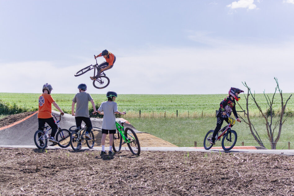
The world-class Coldstream Station Pump Track is located at the station precinct and opened to the public in December 2023. Additional facilities include a car park with solar lighting, public toilets, outdoor furniture, interpretative signage, and a drinking fountain.
Coldstream Station Pump Track is a great place to learn BMX and MTB skills. The track includes beginner, intermediate and advanced lines, catering to riders of all ages and skill levels.
Yarra Ranges Council thanks the Victorian Government and Australian Government for their funding support of Coldstream Station Activation.
View the Coldstream Station Activation Master Plan
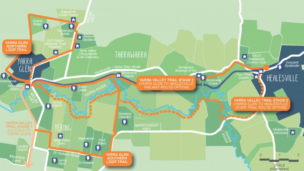
Yarra Valley Trail Stage 2 will wind through the picturesque Yarra Valley between Yarra Glen and Healesville, connecting trail users to some of Australia’s finest wineries, cultural experiences, and tourism destinations. The project will be delivered in two stages.
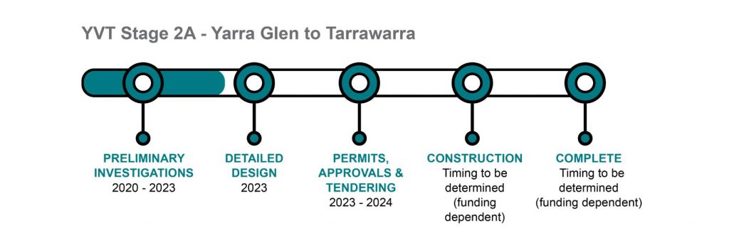
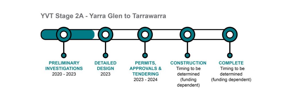
YVT Stage 2A – Yarra Glen to Tarrawarra
PROJECT STATUS: PRE-CONSTRUCTION
YVT Stage 2A will be 4.6km long, departing from the newly refurbished Yarra Glen Railway Station. It will be a shared trail running parallel to Yarra Valley Railway, offering connections to key tourism destinations, and ending at Tarrawarra.
In 2023, Yarra Ranges Council was invited by the Australian government to apply to the Priority Community Infrastructure Program for the construction of YVT Stage 2A. The outcome of that application is pending.
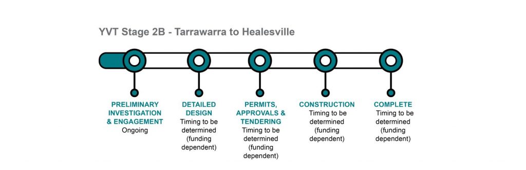
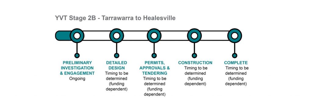
YVT Stage 2B –Tarrawarra to Healesville
PROJECT STATUS: PLANNING
YVT Stage 2B will feature connections to Tarrawarra Estate and Tarrawarra Museum of Art before continuing to Healesville Railway Station.
Yarra Valley Railway operates a heritage diesel rail service from Healesville Station and is working to restore a steam train service through to Yarra Glen.
Council will continue to advocate for State and Federal funding support for this critical community infrastructure project.
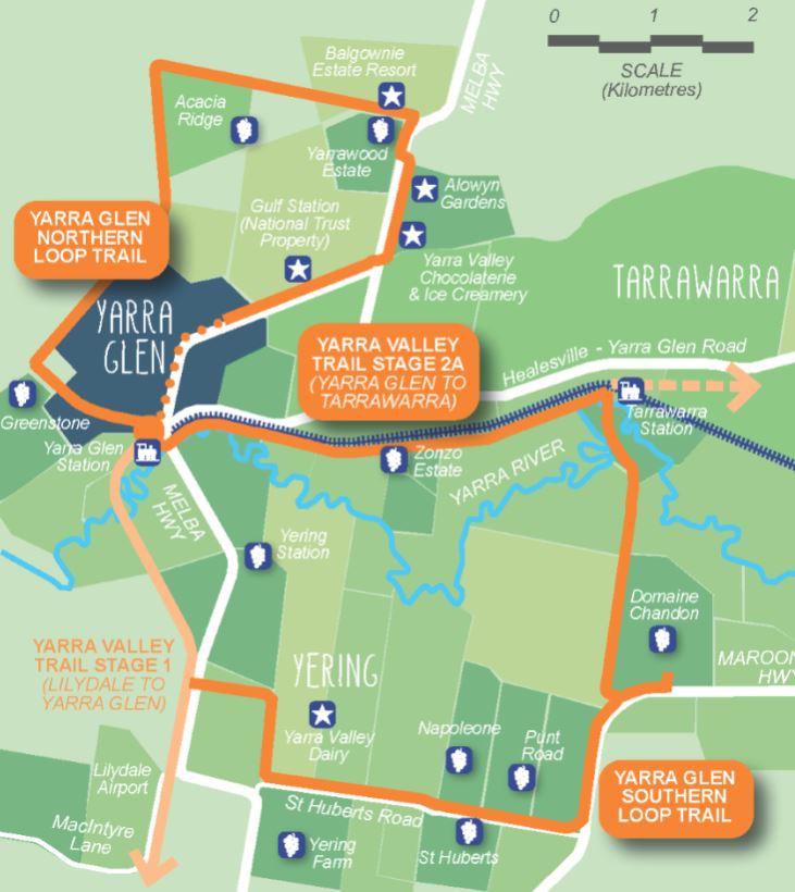
Two moderate length circuits will be constructed, centred on the trail head at Yarra Glen Railway Station. These trails connect to a range of spectacular viewpoints and some of Australia’s best wineries, speciality food, art and cultural experiences and iconic tourism destinations.
YVT Yarra Glen Northern Loop
PROJECT STATUS: UNDER CONSTRUCTION
YVT Northern Loop creates a 14km journey north and east of Yarra Glen Railway Station. This project is being delivered in four sections, each with different delivery timeframes. Sections 1 and 2A are complete, with additional construction planned for 2024.
When complete, YVT Northern Loop will connect trail users to Yarra Valley Chocolaterie and Ice Creamery, Gulf Station, Alowyn Gardens and several wineries.
Yarra Ranges Council thanks the State Government for their funding support of Yarra Glen Northern Loop.
YVT Yarra Glen Southern Loop
PROJECT STATUS: PLANNING
The Southern Loop will detour from Yarra Valley Trail at Yering, connecting trail users to Yarra Valley Dairy and several wineries before re-joining the main trail at Tarrawarra. Completion if the Southern Loop will create an 18km return circuit from Yarra Glen.
Council will continue to advocate for State and Federal funding support for this critical community infrastructure project.
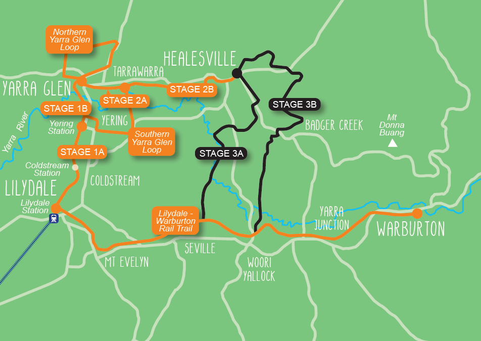
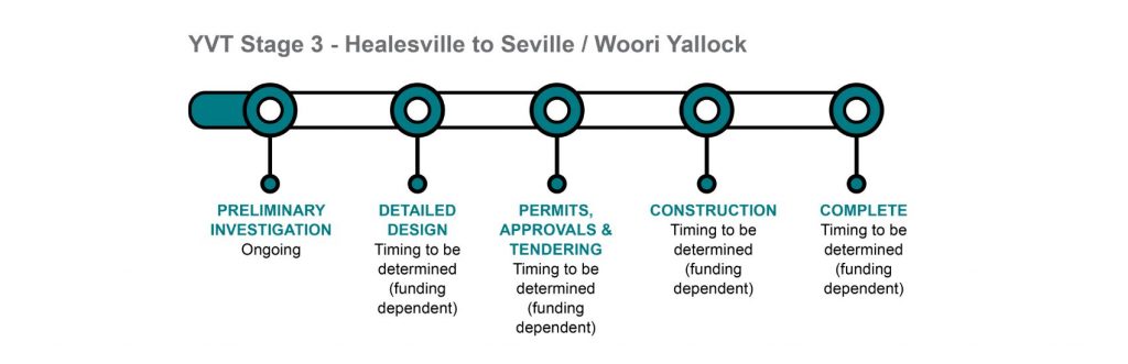
Yarra Valley Trail Stage 3 connects Healesville to the popular Lilydale to Warburton Rail Trail, completing an iconic valley-wide loop, totalling over 80km of world-class trail.
YVT Stage 3A – Healesville to Seville & YVT Stage 3B – Healesville to Woori Yallock
PROJECT STATUS: PLANNING
Two options are available, linking Healesville back to the Lilydale to Warburton Rail Trail.
YVT Stage 3A follows the Birrarung – Yarra River, connecting to the Lilydale to Warburton Rail Trail at Seville while YVT Stage 3B follows Coranderrk Aqueduct to connect at Woori Yallock. Both options will offer wonderful opportunities to experience the natural environment, linking trail users to nature-based attractions including Healesville Sanctuary and Warramate Hills Reserve.
Council will continue to advocate for State and Federal funding support for this critical community infrastructure project.
Project updates
Have a look at what’s been happening with the Yarra Valley Trail project.
Yarra Valley Trail – Northern Loop Update
Council is pleased to announce completion of Yarra Valley Trail Northern Loop, Section 2A. 1.1km of trail between Gulf Road and Henderson Road has [...]

Carrum to Warburton Trail (Olinda Creek Trail)
Carrum to Warburton Trail (Olinda Creek Trail) A section of trail between John Street and Main Street will be blocked and detoured along the [...]
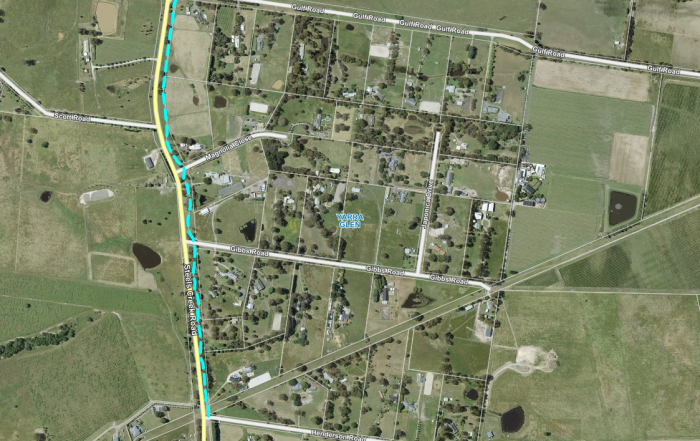
Yarra Ranges Council is upgrading Steels Creek Trail as part of Yarra Valley Trail
Yarra Ranges Council is upgrading Steels Creek Trail as part of Yarra Valley Trail – Yarra Glen Northern Loop. 1.1km of trail between Gulf [...]
Frequently asked questions
Project management
The Yarra Valley Trail will be completed in stages. Timing of each stage is funding dependent. Please refer to Project Stages for the latest information.
The Trail will be built in stages by contractors appointed by Yarra Ranges Council.
Yarra Ranges Council will manage and maintain the Yarra Valley Trail network.
Design considerations
The trail alignment will require some road crossings. These will be designed with traffic engineering input to make sure road crossings are safe.
Yarra Ranges Council works closely with Yarra Valley Railway, including agreement regarding the sharing of facilities at the Yarra Glen Railway Station and keeping the option open for a tourist railway between Yarra Glen and Lilydale in the future.
The existing railway tracks between Lilydale and Yarra Glen are in poor condition and will be removed to accommodate the trail. Extensive bridge and rail construction works will be required to accommodate any future rail provision along the corridor.
The project planning has been undertaken with input from the Traditional Owners and a A Cultural Heritage Management Plan for Stage 1B has been endorsed.
The rail corridor includes several historic timber bridges, but they are not safe for use. These bridges will be retained and returned to a safe standard. Restoration works will preserve as much of the existing structure as possible, reinforcing each bridge were necessary.
Horse riding is permitted on Yarra Valley Trail between Lilydale and Yering. Horse float parking and a tie up area is located at Yering Station. Horse access will be considered for future stages.
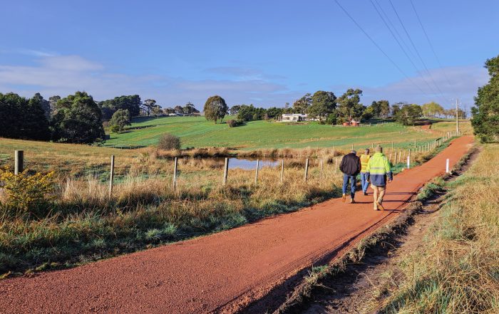
Yarra Valley Trail features a well-formed, unsealed surface, stabilised with a 3% mix of cement where necessary.
This surface type has been selected based upon a range of factors, including commonality with the Lilydale to Warburton Rail Trail, maintaining a rural / natural character, construction cost, and its ability to cater to a wide range of trail users.
Public toilets are located at Lilydale (Main Street) and Coldstream Station. Public toilets will be considered at future trail nodes.
Drinking fountains are located at Beresford Road in Lilydale, Coldstream Station, and at Yering Station.
Picnic tables are located at Beresford Road in Lilydale, Coldstream Station, and Yering Station.
Seating is located at various points along the trail.
Interpretive signage and kilometre marking signs are provided along the trail.
Plan your journey along the Yarra Valley Trail using the Yarra Ranges Council Interactive Trails Map.
Landholders and property owners
The Trail is bordered by several agricultural properties and includes infrastructure associated with agricultural land use, i.e. crossing points for machinery / farm animals and areas that are managed through grazing. Similar mixed land use occurs along the Lilydale to Warburton Rail Trail and is managed successfully.
Careful consideration is given to the needs of residents and businesses during the planning and construction of Yarra Valley Trail.
Community benefits
Yarra Valley Trail will provide a recreational link to gourmet, cultural and tourism destinations and will connect trail users to businesses across the Yarra Valley.
The trail will be a significant tourist destination and is forecast to attract approximately 370,000 visitors to Yarra Ranges each year, including 87,000 overnight visitors. The estimated $33.5 million increase in regional economic spend is a significant opportunity for businesses across Yarra Ranges.
Yarra Valley Trail will:
- Provide an active transport link that connects towns and communities across the Yarra Valley.
- Promote positive social, health and wellbeing outcomes among locals and visitors by offering an accessible form of active recreation and encouraging nature connection.
- Encourage a sustainable increase in visitation to the Yarra Valley. Increase regional spending will support local businesses, create local jobs, and revitalise communities across the Yarra Valley.
Contact Us
Want to know more about the project, or want to leave some feedback? We’d love to hear from you!
Project partners
Yarra Ranges Shire Council
P.O. Box 105, Anderson Street
Lilydale, VIC 3140
T : 1300 368 333